
Your travel insurance becomes worthless the moment you cross into Lebanon’s restricted zones—and the British Embassy cannot rescue you. As of January 2026, the FCDO maintains severe travel restrictions across 80% of Lebanon due to active conflict zones, unpredictable security threats, and voided insurance coverage. If you’re planning essential travel, this guide cuts through bureaucratic jargon to show exactly where you can go, how to stay insured, and the life-saving steps ignored by generic travel sites. Forget tourist brochures; this is the reality check you need before booking flights.
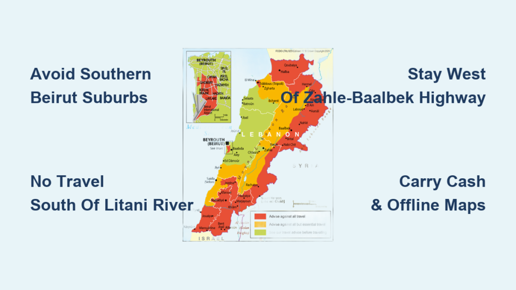
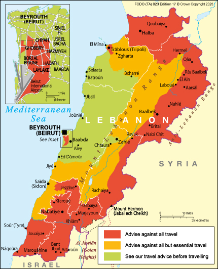
Against All Travel Zones: Absolute No-Go Areas
Southern Beirut Suburbs Beyond Route 51
Do not enter south of Jalloul Street, east of Tariq el Jdideh, or west of Hourch—this includes the war cemetery vicinity. The only safe corridor to Beirut-Rafic Hariri International Airport is Route 51 from central Beirut. Stray outside this strip, and you risk IDF airstrikes reported as recently as December 2025. Travelers who entered the southern suburbs in November 2025 lost all insurance coverage when caught in artillery fire near Chiyah.
South of the Litani River: Complete Ban Includes Tyre
Every location south of the Litani River is strictly prohibited, wiping out popular destinations like Tyre and its ancient ruins. This ban covers:
– Entire Nabatiyeh Governorate (including Nabatiyeh city)
– Jezzine District
– All Palestinian refugee camps (12 official sites like Shatila and Ain el-Hilweh)
Attempting to visit Tyre’s beaches or historical sites voids your insurance and exposes you to ongoing IDF operations near the Blue Line.
Eastern Beqaa & Baalbek Temple Complex Danger Zones
East of the Rachaiya-Marjaayoun Road is off-limits—including Khiam, Hasbaya, and Aanjar. Crucially, Baalbek Temple complex is banned under the “east of Zahle-Baalbek Highway” restriction. Even if you reach Zahle safely, traveling east toward Baalbek invalidates insurance due to reported Hizballah-Hezbollah clashes. The northern boundary ends at Riyaq, where recent airstrikes damaged infrastructure.
Tripoli City and Entire Akkar Governorate
Tripoli’s city boundaries are completely restricted, while Akkar Governorate faces total travel bans. This eliminates northern coastal routes to Syria. Travelers attempting to enter Tripoli in late 2025 faced immediate detention by Lebanese Armed Forces at checkpoints.
Areas Allowing Essential-Only Travel: Navigate with Extreme Caution
Mount Lebanon’s Chouf Mountains Risk Corridor
South of the Khiam El Damour → Mghayreh → Kfar Him road requires “essential travel only”—meaning tourism is not considered essential. Deir El Qamar and the Chouf Mountains fall here. If you must enter:
– Verify daily via Virgin Radio Lebanon (FM 89.5) for protest alerts
– Carry cash (ATMs frequently fail in these zones)
– Never travel after dark due to celebratory gunfire risks
Zahle’s Permitted Travel Pockets
Only three narrow corridors remain accessible in Beqaa Governorate:
1. Aintoura-Zahle Road (including Zahle city)
2. Zahle-Baalbek Highway west side (stay west of the highway!)
3. Barouk-Joub Jannine Road north section
One traveler lost insurance coverage in December 2025 by straying 500 meters east of the Zahle-Baalbek Highway toward Chtoura.
Insurance Void Triggers You Can’t Afford to Ignore
Four Actions That Instantly Cancel Coverage
Your policy becomes invalid if you:
– Enter any zone marked “against all travel” on FCDO maps
– Seek medical help in Nabatiyeh or South Governorate
– Request evacuation from Beirut’s southern suburbs
– File theft claims in Palestinian refugee camps
Critical mistake: Assuming “all-risk” policies cover Lebanon. Verify in writing that your insurer explicitly includes Lebanon and excludes no FCDO-restricted zones.
Non-Negotiable Emergency Coverage Requirements
Before departure, confirm your policy includes:
– Medical evacuation to Cyprus or Jordan (Lebanese hospitals lack capacity for serious trauma)
– 72+ hours of emergency accommodation during border closures
– Repatriation costs if injured in permitted zones
– Satellite phone reimbursement for communication blackouts
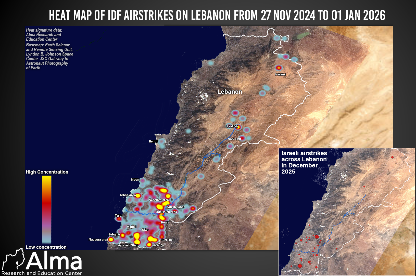
Real-Time Security Threats Beyond the Ceasefire
IDF Operations Near Litani River Despite Ceasefire
The November 2024 Israel-Hizballah ceasefire has not stopped active threats:
– Airstrikes reported in Nabatiyeh Governorate as recently as December 18, 2025
– Artillery fire within 5km of the Litani River’s north bank
– Beirut southern suburbs remain IDF target zones
Pro tip: Download the Lebanon Security Map app showing live IDF patrol routes updated hourly.
Celebratory Gunfire Survival Protocol
When gunfire erupts (common after regional events):
1. Drop immediately behind solid cover—concrete walls, not vehicles
2. Avoid windows—bullets penetrate glass from 1km away
3. Wait 20+ minutes after last shot before moving
4. Never look outside to “see what’s happening”
Three tourists were injured in Zahle in December 2025 by stray bullets during New Year’s “celebrations.”
Airport Transit & Emergency Exit Planning
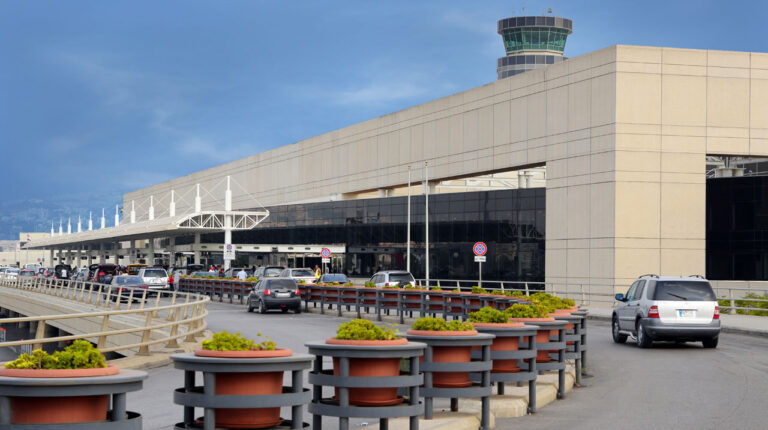
Beirut Airport Road Trip: Do This Before Leaving
Every airport journey requires:
– Real-time security check via Voice of Lebanon (FM 100.3-100.5)
– Two pre-planned detour routes (Route 51 faces surprise roadblocks)
– Embassy contact saved offline (+961 1 960 800)
– Full fuel tank (gas stations near airport frequently close)
Allow 3+ hours for the 20-minute drive to avoid missing flights.
Your Only Viable Escape Routes
Northern Route: Through permitted North Governorate zones toward Ariz (not Tripoli!)
Eastern Route: Via Aintoura-Zahle corridor to Syrian border at Masnaa (verify Syrian entry rules first)
Southern Route: Impossible—Litani River restrictions block all southward movement
Pre-Travel Checklist: Avoid These Fatal Errors
Emergency Plan Must-Haves
Failing to prepare these voids your safety net:
– Three exit strategies per location (e.g., Zahle: north via Aintoura, east via permitted highway, west via Barouk)
– Shelter-in-place contacts (hotel managers with generator access)
– $500+ USD cash (Lebanese pounds lose value hourly during crises)
– Offline maps of permitted zones (Google Maps fails during blackouts)
Daily Security Routine
Skip this at your peril:
– 6:00 AM: Check FCDO email alerts + Virgin Radio’s first broadcast
– Noon: Scan local social media for protest hashtags (#BeirutAlert)
– 5:00 PM: Confirm tomorrow’s road access via hotel concierge
– Before bed: Share location with 2 emergency contacts outside Lebanon
Final Reality Check: Your Survival Depends on This
The British Embassy will not evacuate you from Tripoli, Tyre, or Baalbek—no matter your nationality. In December 2025, seven tourists stranded in Nabatiyeh paid $8,000 each for private helicopter extraction because the UK government denied assistance. Your safety hinges on three non-negotiable rules: stay strictly within permitted zones, carry verified Lebanon-specific insurance, and never assume stability.
Critical reminder: This advisory changes hourly. Bookmark the FCDO Lebanon page and check it before every outing. What was safe at breakfast may be a conflict zone by lunch. If you take one thing from this guide, let it be this: Your travel insurance and embassy support vanish the moment you cross into a restricted zone—and no tour operator will warn you until it’s too late.
Note: All restrictions and advice reflect FCDO updates current as of 4 January 2026. Verify changes before travel at gov.uk/foreign-travel-advice/lebanon.